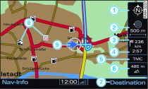
- Fig. 1 Map with deactivated legend menu

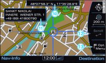
- Fig. 2 Map with activated legend menu

- Fig. 3 Input menu

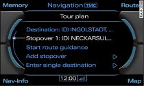
- Fig. 4 Tour plan
As soon as you press the Map control button (while the route guidance function is activated), the map will appear on the MMI display with the legend menu deactivated Fig. 1.
In this display, you can zoom in and out of the map by turning the rotary pushbutton clockwise or anti-clockwise. To select a town, move the crosshairs on the map with the joystick
Link .
You can activate the legend menu Fig. 2 by pressing the rotary pushbutton. Now you can change the map display via the legend menu. To do so, turn the rotary pushbutton to select the point on the map and press the rotary pushbutton.
You can exit the legend menu by pressing RETURN.
| -1- | Orientation. The map is displayed either facing north or facing the direction of travel Link. If you select the orientation option in the activated legend menu and press the rotary pushbutton, the orientation switches from the direction of travel to the direction facing north and vice versa. This setting is stored. |
| -2- | Scale. Turn the rotary pushbutton clockwise/anti-clockwise to zoom in or out. You can also change the scale via the activated legend menu. |
| -3- | Distance to destination/stopover |
| -4- | Calculated time of arrival at destination/stopover |
| -5- | TMC status display |
| -6- | Altitude display |
| -7- | Destination control button. To switch to destination input menu Fig. 3 or the tour plan Fig. 4. |
| -8- | Examples of selected map contents |
| -9- | Location of the vehicle |
| -10- | Display of position coordinates of the crosshairs (longitude and latitude) |
| -11- | If you use the crosshairs to select map contents, any existing information on the contents (e.g. address, phone number or traffic message) will be displayed. |
| -12- | Moving along the route. This function can be used while route guidance is activated. Turn the rotary pushbutton clockwise/anti-clockwise to move the map along the current route. |
| -13- | Map position menu. The point on the map selected with the crosshairs can be set as a destination or stopover, stored in the directory and called up on the telephone Link. The position coordinates of the crosshairs (longitude and latitude) are displayed. |
Note
Did you know that you can choose from four different map types Link?
